


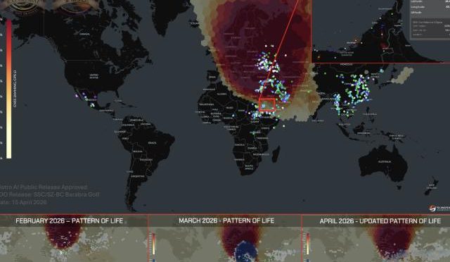


GPS has become so deeply integrated into modern life that most people rarely think about what would happen if satellite navigation suddenly stopped working.
Drivers use GPS to navigate roads. Delivery companies use it to track vehicles. Airlines depend on satellite navigation for many operations. Farmers use GPS-guided equipment, while telecommunications networks and other critical systems can rely on highly accurate timing.
But GPS is not invulnerable.
One of the biggest challenges facing modern navigation systems is GPS jamming.
GPS jamming occurs when a device or transmitter produces radio-frequency interference strong enough to make it difficult for a receiver to detect legitimate GPS signals. Because GPS signals reaching Earth are relatively weak, interference can have a significant impact.
In 2026, GPS resilience has become an increasingly important technology issue in the United States.
The U.S. is responding through several different approaches rather than relying on a single solution. These include modern GPS satellites, improved receivers, anti-jamming technologies, alternative positioning systems, inertial navigation, artificial intelligence, multiple satellite constellations and new approaches such as quantum sensing.
The objective is not simply to make GPS stronger.
The larger goal is to create a navigation ecosystem that can continue functioning when one source becomes unreliable.
That shift could have major implications for aviation, autonomous vehicles, drones, defense, logistics and critical infrastructure.
What Is GPS Jamming?
GPS jamming is a form of radio-frequency interference.
A GPS receiver normally listens for extremely weak signals transmitted by navigation satellites.
A jammer attempts to overwhelm those signals with interference.
When the interference becomes strong enough, the receiver may have difficulty:
- Acquiring GPS satellites
- Maintaining a satellite lock
- Calculating its position
- Determining accurate timing
- Updating navigation information
The result can range from degraded accuracy to complete loss of GPS positioning.
Importantly, GPS jamming is different from GPS spoofing.
GPS Jamming vs GPS Spoofing
These two terms are often confused.
GPS Jamming
The goal is generally to prevent the receiver from using GPS.
The receiver may simply lose its position.
GPS Spoofing
The objective is to mislead the receiver by transmitting signals that cause it to calculate an incorrect position or time.
In simple terms:
Jamming: “You cannot hear GPS.”
Spoofing: “You are hearing false GPS information.”
Both are serious navigation challenges.
Why GPS Signals Can Be Vulnerable
GPS satellites orbit thousands of miles above Earth.
Their signals travel a very long distance before reaching a receiver.
By the time the signals arrive at the surface, they are relatively weak.
This creates a fundamental engineering challenge.
GPS receivers are designed to detect extremely low-power signals.
A sufficiently strong source of interference can therefore make satellite signals difficult to process.
This is one reason navigation resilience requires more than simply improving the satellite constellation.
Why GPS Jamming Matters in the United States
GPS disruption is not only a military concern.
The technology has become part of everyday civilian infrastructure.
Consider a modern city.
Thousands of vehicles may be using navigation systems simultaneously.
Delivery companies track fleets.
Airports operate complex navigation systems.
Telecommunications infrastructure uses precise timing.
Emergency services use location technologies.
Businesses depend on synchronized systems.
This means widespread GPS disruption could have consequences beyond a person simply getting lost.
GPS and Aviation
Aviation is one of the areas where GPS resilience receives significant attention.
Aircraft use satellite navigation as part of modern navigation systems, while aviation authorities also maintain other navigation capabilities and augmentation systems.
The FAA states that GPS is an important component of the U.S. National Airspace System and supports navigation through multiple augmentation technologies.
GPS interference can therefore create operational challenges.
Pilots and aviation systems need to recognize when satellite navigation is unreliable and use appropriate alternative procedures.
This is why aviation technology increasingly focuses on resilient navigation rather than assuming GPS will always be available.
GPS Jamming and Autonomous Vehicles
Autonomous vehicles create another important challenge.
A human driver can often recognize when a navigation application is wrong.
An autonomous vehicle has a much more complicated problem.
It must determine its location and movement using multiple sensors.
A modern autonomous vehicle can potentially combine:
- GPS
- Cameras
- Radar
- LiDAR
- Inertial sensors
- Digital maps
- Wheel-speed information
- AI-based localization
GPS is useful because it provides a global reference.
But if GPS disappears, the vehicle still needs to understand where it is.
This makes GPS resilience an important part of autonomous driving technology.
Why Self-Driving Cars Cannot Depend Only on GPS
GPS is not precise enough by itself for every autonomous-driving task.
A vehicle needs to know much more than its approximate latitude and longitude.
It must understand:
- Which lane it occupies
- Where nearby vehicles are
- Where intersections are located
- Where road boundaries are
- Whether an obstacle is present
- How fast it is moving
- How its surroundings are changing
That is why autonomous systems use sensor fusion.
GPS provides one source of information.
Cameras, radar, LiDAR and inertial systems provide others.
This approach also provides resilience when one sensor becomes unreliable.
GPS Jamming and Drones
Drones are another technology increasingly affected by GPS reliability.
Many drones use GPS for:
- Position holding
- Navigation
- Mapping
- Automated flight
- Return-to-home functions
- Route planning
A GPS outage can therefore interfere with normal operations.
Commercial drones may have additional navigation systems.
Advanced systems can use visual navigation, inertial sensors and other technologies.
Future drone platforms may increasingly combine several independent navigation sources.
GPS Resilience in Logistics
Modern logistics depends heavily on location technology.
A delivery fleet may have hundreds or thousands of vehicles.
GPS allows companies to monitor:
- Vehicle locations
- Routes
- Estimated arrival times
- Delivery progress
- Fleet efficiency
If GPS becomes unavailable, logistics companies can potentially rely on other positioning sources.
But the transition is not always seamless.
This is why resilient positioning is becoming a valuable technology capability.
GPS Timing Is Another Major Concern
GPS is not only a positioning technology.
It is also an important source of precise time.
Many systems need accurate clocks.
Examples include:
- Telecommunications networks
- Electrical grids
- Financial systems
- Data centers
- Scientific equipment
- Transportation infrastructure
GPS timing can help synchronize distributed systems.
A disruption in GPS can therefore create challenges even for systems that do not use GPS for navigation.
What Is PNT?
The term PNT stands for:
Positioning, Navigation and Timing.
GPS is one of the most important components of the PNT ecosystem.
But modern U.S. technology strategy increasingly focuses on resilient PNT.
That means ensuring that positioning, navigation and timing remain available even if one system fails or becomes unreliable.
The U.S. Space Force’s long-term planning describes a future PNT architecture that uses multiple sources rather than depending exclusively on GPS.
The United States Is Modernizing GPS
One response to GPS threats is to modernize the GPS constellation.
The GPS III generation provides improved capabilities compared with earlier generations.
In April 2026, the U.S. Space Force announced the successful launch of the tenth and final GPS III satellite, completing the GPS III series.
But modernization is continuing.
The next generation, GPS IIIF, is already under development.
GPS IIIF and Navigation Resilience
GPS IIIF is intended to build on the capabilities of GPS III.
The program is part of the United States’ long-term effort to maintain a modern satellite navigation constellation.
In June 2026, Space Systems Command announced a contract option for two additional GPS IIIF satellites worth $514.4 million, bringing the total number of GPS IIIF satellites under contract to 14.
The continued investment shows that the U.S. expects satellite navigation to remain strategically important for decades.
M-Code and Modern Military GPS
One important technology associated with modern GPS satellites is M-Code.
M-Code is a modernized military GPS signal intended to provide improved security and resistance to interference for authorized military users.
Modern military navigation cannot assume that satellite signals will always be available without interference.
Military systems therefore require additional capabilities.
GPS modernization is one component of this effort.
AI Could Help Detect GPS Interference
Artificial intelligence could become increasingly important for GPS resilience.
A navigation system can compare multiple information sources.
For example:
GPS reports one position.
The vehicle’s inertial sensors report another.
The camera-based localization system reports a third.
The digital map predicts a fourth.
AI can analyze these differences.
If GPS suddenly becomes inconsistent with every other sensor, the system could lower its confidence in the GPS measurement.
This could help identify potential interference or spoofing.
Sensor Fusion Is the Future of Navigation
Sensor fusion means combining multiple sources of information into one navigation solution.
A future vehicle might use:
GPS
Global positioning reference.
IMU
Movement and acceleration measurements.
Camera
Visual localization.
LiDAR
Three-dimensional environmental information.
Radar
Object and distance information.
AI
Data analysis and anomaly detection.
Digital Maps
Geographic reference.
This makes the system much less dependent on a single source.
Inertial Navigation as a Backup
Inertial navigation has existed for decades.
An inertial measurement unit uses sensors to measure:
- Acceleration
- Rotation
- Movement
The system can estimate position without continuously receiving GPS signals.
The major problem is drift.
Small measurement errors accumulate over time.
This means inertial navigation works particularly well when periodically corrected by GPS or another external reference.
Modern navigation systems therefore often combine GPS with inertial navigation.
Quantum Sensors Could Improve GPS-Denied Navigation
Quantum sensing is an emerging technology that could eventually improve GPS-independent navigation.
Quantum sensors can potentially measure physical quantities with extremely high sensitivity.
Researchers are exploring whether quantum sensors can improve inertial navigation and other positioning techniques.
The potential benefit is significant.
A system could continue measuring its movement even when GPS signals are unavailable.
This technology remains under development, but it is becoming an increasingly interesting part of future navigation research.
LEO Satellites Could Add Another Layer
Low Earth Orbit satellites are also attracting attention in the navigation industry.
LEO satellites operate much closer to Earth than traditional GPS satellites.
Some emerging navigation concepts use LEO satellite signals as an additional source of positioning and timing information.
The benefit is diversity.
Instead of depending only on GPS satellites, a receiver could potentially use multiple satellite systems.
This could make navigation more resilient.
Multi-GNSS Navigation
GPS is operated by the United States, but it is not the world’s only satellite navigation system.
Other major GNSS systems include:
- Galileo
- GLONASS
- BeiDou
Modern receivers can support multiple constellations.
Using several satellite systems can increase the number of available signals.
It can also improve navigation availability in difficult environments.
Multi-GNSS is therefore another important part of resilient positioning.
What Happens When GPS Is Lost?
A modern navigation system does not necessarily stop working immediately.
Suppose a vehicle loses GPS.
Its navigation system may still have:
- Inertial measurements
- Camera information
- Map data
- Radar information
- Wheel-speed measurements
The system can continue estimating position.
However, the accuracy may gradually decline depending on the sensors and environment.
When GPS becomes available again, the navigation system can use it to correct accumulated error.
This is one of the key principles behind resilient navigation.
GPS Jamming in Urban Environments
Cities present unique navigation challenges.
Tall buildings can block or reflect satellite signals.
This can create multipath effects.
Add radio-frequency interference to the environment and navigation becomes even more complicated.
Future systems will therefore need to distinguish between:
- Normal urban signal problems
- Temporary GPS outages
- Intentional jamming
- Spoofing
- Sensor failures
AI and sensor fusion could help make these decisions.
GPS Jamming and Critical Infrastructure
Critical infrastructure is another reason resilient PNT matters.
Modern infrastructure increasingly depends on digital systems.
Power networks, communications systems and transportation infrastructure can use precise timing.
A resilient architecture means operators do not have to depend entirely on one external timing source.
Alternative timing systems can provide redundancy.
This is an important principle in critical infrastructure design:
If one source fails, another should be available.
Why GPS Modernization Alone Is Not Enough
New GPS satellites are important.
But they cannot solve every navigation problem.
A receiver can still experience:
- Local interference
- Antenna problems
- Signal obstruction
- Spoofing
- Equipment failure
That is why the future of navigation is likely to involve multiple technologies.
The satellite constellation is only one component.
The Future GPS System Will Be Multi-Layered
The navigation system of the future could contain several layers.
Layer 1: GPS
Global satellite navigation.
Layer 2: Other GNSS
Additional satellite constellations.
Layer 3: LEO Satellites
Alternative satellite signals.
Layer 4: Inertial Navigation
Independent movement measurement.
Layer 5: Vision
Camera-based positioning.
Layer 6: Radar and LiDAR
Environmental localization.
Layer 7: AI
Intelligent sensor fusion.
Layer 8: Quantum Sensors
Potential high-precision GPS-independent navigation.
This architecture would be considerably more resilient than a GPS-only approach.
GPS Jamming and Military Technology
Military users have some of the strongest reasons to develop GPS-independent navigation.
Operations may occur in environments where satellite signals are deliberately targeted.
A military vehicle, aircraft, ship or other platform cannot simply stop navigating when GPS becomes unavailable.
This has driven significant interest in:
- Secure GPS
- Anti-jamming technology
- Anti-spoofing systems
- Inertial navigation
- Alternative PNT
- Terrain navigation
- Celestial navigation
- Quantum sensing
The goal is not to eliminate GPS.
It is to make systems less dependent on GPS alone.
The U.S. Space Force and Resilient PNT
The U.S. Space Force’s long-term planning reflects this changing approach.
Its future vision includes diversified navigation sources and onboard capabilities rather than assuming GPS will always be available.
This is an important technological transition.
GPS remains central.
But the architecture around GPS is becoming much broader.
GPS and the Internet of Things
The Internet of Things, or IoT, is creating another demand for accurate location information.
Connected devices can include:
- Vehicles
- Industrial equipment
- Agricultural machines
- Shipping containers
- Infrastructure sensors
Many of these systems may use location and timing information.
As IoT networks grow, reliable positioning becomes increasingly valuable.
Could GPS Jamming Affect Smartphones?
Yes, smartphones can experience GPS-related positioning problems when satellite signals are blocked or heavily interfered with.
However, modern smartphones do not rely exclusively on GPS.
They can also use:
- Wi-Fi
- Cellular networks
- Bluetooth
- Device sensors
- Other GNSS constellations
This is another example of multi-source positioning.
The phone may continue providing an approximate location even when GPS performance is degraded.
Why Navigation Resilience Will Become More Important
The world is becoming more automated.
Autonomous systems require dependable positioning.
A human can adapt when navigation fails.
An autonomous machine needs software and sensors to make that decision automatically.
This creates a stronger requirement for resilient navigation.
As autonomy increases, GPS resilience will become less of a specialized military issue and more of a mainstream technology requirement.
GPS Jamming and the Future of Smart Transportation
Future transportation systems could depend on several navigation sources.
Connected vehicles could exchange information.
Road infrastructure could provide positioning information.
Vehicles could use high-definition maps.
Satellite navigation could provide global reference.
AI could continuously compare all sources.
This would make transportation systems more robust.
The Role of Hardware Manufacturers
Resilient GPS is not only about satellite operators.
Hardware manufacturers also play a major role.
Modern receivers can be designed with:
- Better filtering
- Multi-frequency support
- Multi-GNSS capability
- Anti-spoofing algorithms
- Improved signal processing
- Inertial sensors
Future receivers could also integrate quantum sensors and advanced AI.
This means the navigation hardware industry will continue evolving alongside satellite technology.
What Consumers Can Expect
For ordinary users, GPS modernization may not produce a dramatic change overnight.
Maps will still look familiar.
Navigation apps will still provide directions.
Cars will still display routes.
But the technology underneath these services will become more resilient.
Future vehicles and devices may quietly combine many sources to maintain location accuracy.
Consumers may never know when the system switches from one navigation source to another.
Frequently Asked Questions
What is GPS jamming?
GPS jamming is radio-frequency interference that disrupts a receiver’s ability to detect or use legitimate GPS satellite signals.
What is the difference between GPS jamming and spoofing?
Jamming attempts to disrupt GPS reception, while spoofing attempts to provide false information that can cause a receiver to calculate an incorrect location or time.
Can GPS III resist jamming?
GPS III includes modernized capabilities intended to improve resilience, while military users also have access to technologies such as M-Code. No GPS system should be considered completely immune to interference.
Is GPS jamming a problem for civilian technology?
It can be. Aviation, transportation, logistics, agriculture, drones and other civilian applications can potentially be affected by GPS interference.
Can a car navigate without GPS?
Yes. Vehicles can use inertial sensors, cameras, maps and other technologies, although the accuracy and duration of GPS-independent navigation depend on the system.
What is resilient PNT?
Resilient PNT means maintaining reliable positioning, navigation and timing through multiple technologies and backup sources instead of depending entirely on one system.
Will AI replace GPS?
No. AI can help combine and evaluate navigation information, but it does not replace the underlying positioning sources.
Could quantum sensors replace GPS?
Not in the near term. Quantum sensing is better viewed as a potential complementary technology for GPS-independent navigation.
Why is the USA investing in GPS IIIF?
GPS IIIF is part of the long-term modernization of the U.S. GPS constellation and is intended to provide future capabilities as older spacecraft are replaced.
Conclusion
GPS has become one of the most important technologies in the modern world.
But the future of navigation is changing.
GPS jamming, spoofing, signal obstruction and increasingly complex technology requirements are forcing engineers to think beyond traditional satellite navigation.
The United States is responding through a combination of satellite modernization and alternative navigation technologies.
The completion of the GPS III series in 2026 is an important milestone.
At the same time, GPS IIIF is moving forward, with 14 satellites under contract following additional procurement announced in June 2026.
But satellites are only part of the answer.
The future navigation ecosystem will likely combine:
GPS + Multi-GNSS + LEO Satellites + Inertial Navigation + AI + Sensors + Alternative PNT + Quantum Technology
This multi-layered approach can provide greater resilience.
For autonomous vehicles, it could help maintain localization during GPS outages.
For drones, it could provide additional navigation options.
For aviation, it could improve resilience against interference.
For military systems, it could provide navigation capabilities in GPS-denied environments.
For critical infrastructure, alternative timing sources could reduce dependence on a single external system.
The most important change is therefore conceptual.
The future is not about asking:
“How can we make GPS do everything?”
Instead, engineers are increasingly asking:
“How can we make navigation continue working even when GPS is unavailable?”
That question is driving the development of resilient PNT, advanced GPS receivers, AI-based sensor fusion, alternative satellite systems and quantum navigation.
GPS will almost certainly remain at the center of global positioning for many years.
But the GPS system of the future will be surrounded by a much larger technological ecosystem.
The next generation of navigation will not simply be more accurate. It will be more intelligent, more secure and much more resilient.


